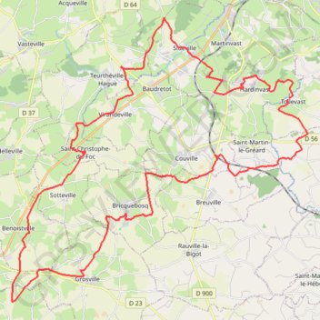
La tollevataise 2019
- Distance: 51.4 Km
- Elevation gain: 821 m
- Maximum elevation: 150 m
- Elevation loss: 816 m
- Minimum elevation: 27 m
- Moving time: 3 h 19 m
- Moving speed: 15.4 Km/h
- Maximum speed: 67.4 Km/h
- Total time: 3 h 31 m
- Global speed: 14.6 Km/h
- Date: 12/10/2019
Interactive map
GPS track profile
About this GPS track
Name: La tollevataise 2019 GPS track, route, trail
Coordinates: 49.50037 -1.78345 49.60412 -1.61712
Other GPS tracks
Click on a GPS track to view route, its statistics and profile.
Tour d'Europe
France > Bretagne > Finistère > Concarneau > Landan Creis
Distance: 7,132.9 Km • Elevation gain: 44,603 m • Maximum elevation: 2,433 m
GR223 - Cherbourg à Coutances
France > Normandie > Manche > Cherbourg-en-Cotentin
Randonnée entre Cherbourg-Octeville et Coutances. #Randonnée
Distance: 201.4 Km • Elevation gain: 2,106 m • Maximum elevation: 138 m
Sentier Cotentin - Cherbourg vers Mont-Saint-Michel
France > Normandie > Manche > La Hague > Urville-Nacqueville > La Rivière
Distance: 231.7 Km • Elevation gain: 2,584 m • Maximum elevation: 128 m
GR 223 Tour du Cotentin (2021)
France > Normandie > Eure > Berville-sur-Mer
Randonnée en Normandie sur le GR 223 autour du Cotentin à travers l'Eure, le Calvados et la Manche de Berville-sur-Mer au Mont-Saint-Michel.
Distance: 650.7 Km • Elevation gain: 6,685 m • Maximum elevation: 149 m
Randonnée de Cherbourg à Portbail par le GR 223
France > Normandie > Manche > Cherbourg-en-Cotentin
Randonnée sur sentier du littoral à travers la Manche de Cherbourg à Portbail via Equeurdreville, Urville-Nacqueville, Hameau aux Fèvres (Greville-Hague), Digulleville, Herqueville, Biville, Les Pieux, Surtainville, Baubigny, Barneville-Carteret et Barneville-Carteret. #Randonnée #GR223 #Normandie #Manche #Mer #Nature
Distance: 110.6 Km • Elevation gain: 2,100 m • Maximum elevation: 131 m
La Barjo
France > Normandie > Manche > La Hague > Beaumont-Hague > Le Hameau Sauvage
Trail de 80 km
Distance: 81.1 Km • Elevation gain: 2,026 m • Maximum elevation: 174 m
Etape 2 du Raid de l'Archange
France > Normandie > Manche > Carteret > Le Valnotte
De Carteret à Lestre
Distance: 79.8 Km • Elevation gain: 631 m • Maximum elevation: 114 m
1 - Vélo 2024 - 100 km
France > Normandie > Manche > Martinvast > Les Rosées
Cyclisme sur routes départementales et communales
Distance: 100.0 Km • Elevation gain: 1,066 m • Maximum elevation: 178 m
2 - Vélo 2024 - 62.3 km
France > Normandie > Manche > Martinvast
Circuit vélo - 63 km
Distance: 62.2 Km • Elevation gain: 790 m • Maximum elevation: 178 m
GR 223 : De Carentan à Cherbourg (Manche)
France > Normandie > Manche > Carentan-les-Marais
Randonnée en Normandie sur le GR 223, Le sentier du littoral, à travers la Manche de Carentan à Cherbourg via Brucheville, Sainte-Mère-Église, Tatihou (Saint-Vaast-la-Hougue), Saint-Vaast-la-Hougue et Saint-Pierre-Église. #Randonnée #GR223 #Mer #Campagne #Manche #Normandie #Cotentin #Nature
Distance: 128.6 Km • Elevation gain: 694 m • Maximum elevation: 149 m
4 - Vélo 2024 - 13 ou 10 km
France > Normandie > Manche > Martinvast
Circuit Vélo famille 13 ou 10 km
Distance: 13.0 Km • Elevation gain: 135 m • Maximum elevation: 65 m
5 - 2024 Rando Pédestre 14.2 km
France > Normandie > Manche > Martinvast
Rando pédestre - 14 km
Distance: 14.2 Km • Elevation gain: 285 m • Maximum elevation: 169 m
6 - 2024 Rando Pédestre 7.8 km
France > Normandie > Manche > Martinvast
Circuit pédestre 8 km
Distance: 7.8 Km • Elevation gain: 134 m • Maximum elevation: 128 m
3 - Vélo 2024 - 36 km
France > Normandie > Manche > Martinvast
Circuit vélo - 36 km
Distance: 35.9 Km • Elevation gain: 486 m • Maximum elevation: 178 m
1 - RDC 2024 VTT 57 km
France > Normandie > Manche > Flamanville > Marcanville
RDC 2024 VTT 57 km
Distance: 57.5 Km • Elevation gain: 977 m • Maximum elevation: 140 m
1 - RDC 2024 VTT 38 km
France > Normandie > Manche > Flamanville > Marcanville
RDC 2024 VTT 38 km
Distance: 37.7 Km • Elevation gain: 630 m • Maximum elevation: 129 m
1 - RDC 2024 VTT 27 km
France > Normandie > Manche > Flamanville > Marcanville
RDC 2024 VTT 27km
Distance: 27.5 Km • Elevation gain: 440 m • Maximum elevation: 96 m
RAF 2022 / 2600 n1 News
France > Hauts-de-France > Pas-de-Calais > Le Touquet-Paris-Plage
Distance: 2,594.8 Km • Elevation gain: 39,725 m • Maximum elevation: 2,766 m
MICHEL LAIR
France > Normandie > Manche > Cherbourg-en-Cotentin
Michel Lair
Distance: 18.7 Km • Elevation gain: 231 m • Maximum elevation: 146 m
Nouveau parcours
France > Normandie > Manche > Helleville
Helleville -Héauville 50 Manche
Distance: 14.8 Km • Elevation gain: 177 m • Maximum elevation: 138 m
GR22 - De Cherbourg à Flamanville
France > Normandie > Manche > Cherbourg-en-Cotentin
Randonnée entre Cherbourg-Octeville et Flamanville. #Randonnée
Distance: 70.2 Km • Elevation gain: 1,477 m • Maximum elevation: 131 m
Rando cap de la Hague
France > Normandie > Manche > La Hague > Urville-Nacqueville > La Rivière
Randonnée entre Urville-Nacqueville et Baubigny. #Randonnée
Distance: 79.8 Km • Elevation gain: 1,378 m • Maximum elevation: 130 m
Itinéraire de Nemours à Nemours
France > Centre-Val de Loire > Loiret > Bromeilles > Bainvilliers
Distance: 1,576.4 Km • Elevation gain: 8,536 m • Maximum elevation: 238 m
1 - sidevillaise-18525602-1710246214-973
France > Normandie > Manche > Sideville > Village de l'Église
La Sidevillaise (substitution)
Distance: 5.3 Km • Elevation gain: 52 m • Maximum elevation: 51 m
1 - etape-3-tdn-2024-parcours (1)
France > Normandie > Manche > Coutances
Etape 3 16 mars 2024
Distance: 137.1 Km • Elevation gain: 1,831 m • Maximum elevation: 157 m
Carentan (50500), Carentan-les-Marais, Manche, Normandie, France - Caen (14000), Calvados, Normandie, France
France > Normandie > Manche > Carentan-les-Marais
Distance: 368.5 Km • Elevation gain: 3,444 m • Maximum elevation: 263 m
Relais des 4 Châteaux - Tourlaville
France > Normandie > Manche > Cherbourg-en-Cotentin
Distance: 51.3 Km • Elevation gain: 1,150 m • Maximum elevation: 175 m
La Tollevastaise
France > Normandie > Manche > Tollevast
VTT. En boucle depuis Tollevast. #VTT #Boucle #Tollevastaise #Cotentin
Distance: 53.3 Km • Elevation gain: 908 m • Maximum elevation: 178 m
Track-Saint Jean de Luz
Belgique > Hainaut > Ath > Lessines
Distance: 1,192.3 Km • Elevation gain: 9,493 m • Maximum elevation: 486 m
Track-Saint de Luz retour
France > Nouvelle-Aquitaine > Pyrénées-Atlantiques > Saint-Jean-de-Luz
Distance: 1,133.5 Km • Elevation gain: 6,888 m • Maximum elevation: 257 m