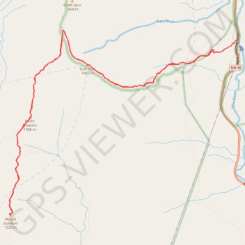
Mount Isolation, North Isolation and Gulf Peak
Hike to Mount Isolation via Glen Boulder Trail, Gulf Peak, Davis Path, North Isolation and Isolation Trail in the White Mountain National Forest, the Pinkham North Scenic Area and the Presidential Range-Dry River Wilderness. #Hike #Mountain #Nature #Forest #Wilderness
- Distance: 17.4 Km
- Elevation gain: 1,411 m
- Maximum elevation: 1,572 m
- Elevation loss: 1,510 m
- Minimum elevation: 599 m
- Moving time: 6 h 22 m
- Moving speed: 2.7 Km/h
- Maximum speed: 5.3 Km/h
- Total time: 7 h 19 m
- Global speed: 2.4 Km/h
- Date: 21/08/2023
Interactive map
GPS track profile
About this GPS track
Name: Mount Isolation, North Isolation and Gulf Peak GPS track, route, trail
Start: Glen Boulder Trail, Pinkham's Grant, Coös County, New Hampshire, United States (44.24400 -71.25946)
Coordinates: 44.21485 -71.30951 44.24748 -71.25369
Other GPS tracks
Click on a GPS track to view route, its statistics and profile.