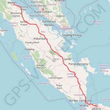
Kualanamu International Airport to Jakarta, Indonesia
- Distance: 1,809.2 Km
- Elevation gain: 10,977 m
- Maximum elevation: 125 m
- Elevation loss: 10,977 m
- Minimum elevation: 0 m
Interactive map
GPS track profile
About this GPS track
Name: Kualanamu International Airport to Jakarta, Indonesia GPS track, route, trail
Coordinates: -6.19454 98.85486 3.63000 106.82288
Other GPS tracks
Click on a GPS track to view route, its statistics and profile.
Bukit Timah Hill - MacRitchie Reservoir
Singapore > Southwest > Singapore
#Hike
Distance: 14.8 Km • Elevation gain: 290 m • Maximum elevation: 167 m
The Green Corridor - Singapore
Singapore > Northwest > Singapore
#Hike
Distance: 22.3 Km • Elevation gain: 167 m • Maximum elevation: 44 m
Singapore Botanical Gardens
Distance: 10.6 Km • Elevation gain: 161 m • Maximum elevation: 40 m
Directions from Duck Tour Ramp to Marina Boulevard, Singapore
Singapore > Central > Singapore
Distance: 105.3 Km • Elevation gain: 812 m • Maximum elevation: 51 m
Singapore East Coast Park
Singapore > Southeast > Singapore
#Hike
Distance: 12.6 Km • Elevation gain: 79 m • Maximum elevation: 22 m
Sungei Buloh Wetland Route
Singapore > Southwest > Singapore
Enjoy the tranquility and serenity of the mangrove habitat is through Route 1. This route goes around the two main ponds and gives a good introduction to the Reserve and the birds of Sungei Buloh, especially during the migratory season from September to March From https://www.aussiebushwalking.com/overseas/sungei-buloh-wetland-route-1
Distance: 2.6 Km • Elevation gain: 16 m • Maximum elevation: 9 m
Singapore Botanical Gardens.gpx
Singapore > Central > Singapore
Distance: 10.6 Km • Elevation gain: 161 m • Maximum elevation: 40 m
Singapore Botanical Gardens
Singapore > Central > Singapore
Distance: 10.6 Km • Elevation gain: 161 m • Maximum elevation: 40 m
Labrador Park
Singapore > Central > Singapore
#Hike
Distance: 8.0 Km • Elevation gain: 91 m • Maximum elevation: 27 m
Pipeline TGI by AGM
Indonesia > South Sumatra > Tungkal Jaya > Beji Mulyo
Distance: 531.4 Km • Elevation gain: 1,808 m • Maximum elevation: 97 m
0918112102-54209
Singapore > Southeast > Singapore
Distance: 0.5 Km • Elevation gain: 3 m • Maximum elevation: 18 m