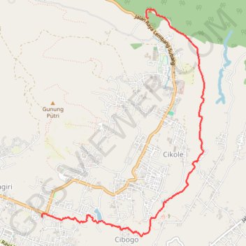
Rando en Indonésie (Lembang)
Randonnée pédestre. En aller simple. #Randonnée
- Distance: 7.8 Km
- Elevation gain: 129 m
- Maximum elevation: 1,341 m
- Elevation loss: 277 m
- Minimum elevation: 1,137 m
- Moving time: 2 h 17 m
- Moving speed: 3.4 Km/h
- Maximum speed: 12.5 Km/h
- Total time: 2 h 36 m
- Global speed: 3.0 Km/h
- Date: 09/06/2011
Interactive map
GPS track profile
About this GPS track
Name: Rando en Indonésie (Lembang) GPS track, route, trail
Start: Kabupaten Bandung Barat, Java occidental, Jawa, 40931, Indonésie (-6.78246 107.65056)
End: Jayagiri, Kabupaten Bandung Barat, Java occidental, Jawa, 40391, Indonésie (-6.81275 107.63420)
Coordinates: -6.81612 107.63410 -6.78121 107.65924