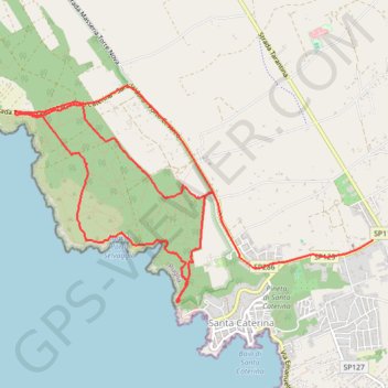
2022-05-26_09-56_Thu
- Distance: 12.6 Km
- Elevation gain: 247 m
- Maximum elevation: 76 m
- Elevation loss: 223 m
- Minimum elevation: 0 m
- Moving time: 2 h 26 m
- Moving speed: 5.2 Km/h
- Maximum speed: 55.0 Km/h
- Total time: 4 h 43 m
- Global speed: 2.7 Km/h
- Date: 26/05/2022
Interactive map
GPS track profile
About this GPS track
Name: 2022-05-26_09-56_Thu GPS track, route, trail
Coordinates: 40.14278 17.95778 40.16211 17.99952
Other GPS tracks
Click on a GPS track to view route, its statistics and profile.
2022-05-26_09-56_Thu-modifie
Italie > Pouilles > Lecce > Nardò > Santa Caterina
Distance: 7.9 Km • Elevation gain: 183 m • Maximum elevation: 76 m