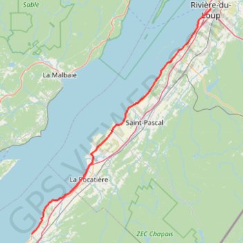
Saint-Jean-Port-Joli - Rivière-du-Loup
Saint Lawrence River. #Bike #SaintJeanPortJoli #RivièreDuLoup #SaintLawrence
- Distance: 93.6 Km
- Elevation gain: 371 m
- Maximum elevation: 58 m
- Elevation loss: 333 m
- Minimum elevation: 0 m
Interactive map
GPS track profile
About this GPS track
Name: Saint-Jean-Port-Joli - Rivière-du-Loup GPS track, route, trail
Coordinates: 47.21790 -70.26524 47.83703 -69.53546
Other GPS tracks
Click on a GPS track to view route, its statistics and profile.
Rivière-du-Loup - Rimouski
Canada > Quebec > Rivière-du-Loup (MRC) > Rivière-du-Loup
Saint Lawrence River. #Bike #RivièreDuLoup #Rimouski #SaintLawrence
Distance: 100.5 Km • Elevation gain: 533 m • Maximum elevation: 121 m
Rivière-du-Loup - Témiscouata-sur-le-Lac
Canada > Quebec > Rivière-du-Loup (MRC) > Rivière-du-Loup
#Bike #RivièreDuLoup #Témiscouata
Distance: 71.8 Km • Elevation gain: 581 m • Maximum elevation: 406 m
Québec - Saint-Jean-Port-Joli
Canada > Quebec > Urban agglomeration of Québec > Quebec
Saint Lawrence River. #Bike #Québec #SaintJeanPortJoli
Distance: 95.2 Km • Elevation gain: 476 m • Maximum elevation: 82 m