Har Turan
Loop running from Rumana. #Run #Loop #Mountain #Nature #Forest #Countryside
- Distance: 26.9 Km
- Elevation gain: 652 m
- Maximum elevation: 542 m
- Elevation loss: 652 m
- Minimum elevation: 150 m
- Moving time: 3 h 41 m
- Moving speed: 7.3 Km/h
- Maximum speed: 24.4 Km/h
- Total time: 3 h 41 m
- Global speed: 7.3 Km/h
- Date: 11/02/2024
Interactive map
GPS track profile
About this GPS track
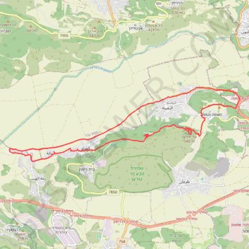
Name: Har Turan GPS track, route, trail
Start: Al Batuf Regional Council, Jezreel Subdistrict, North District, 1710801, Israel (32.78771 35.31283)
End: Al Batuf Regional Council, Jezreel Subdistrict, North District, Israel (32.78783 35.31306)
Coordinates: 32.78486 35.29242 32.81334 35.39794
Other GPS tracks
Click on a GPS track to view route, its statistics and profile.