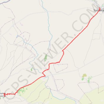
De Torremaggiore à Castelnuovo della Daunia
Randonnée depuis Torremaggiore. #Randonnée
- Distance: 21.9 Km
- Elevation gain: 446 m
- Maximum elevation: 483 m
- Elevation loss: 144 m
- Minimum elevation: 117 m
Interactive map
GPS track profile
About this GPS track
Name: De Torremaggiore à Castelnuovo della Daunia GPS track, route, trail
Start: Via Mons. Giuseppe Lariccia, Torremaggiore, Foggia, Pouilles, 71017, Italie (41.69094 15.28687)
Coordinates: 41.58007 15.12809 41.69094 15.28856
Other GPS tracks
Click on a GPS track to view route, its statistics and profile.
Percorso selezionato
Italie > Lombardie > Côme > Côme
Percorso calcolato con http://www.bicitalia.org/it/routing-gpx
Distance: 1,543.9 Km • Elevation gain: 17,951 m • Maximum elevation: 1,034 m
De Castelnuovo della Daunia à Avellaneta San Marco La Catola
Italie > Pouilles > Foggia > Castelnuovo della Daunia
Randonnée pédestre. En aller simple. #Randonnée
Distance: 18.7 Km • Elevation gain: 823 m • Maximum elevation: 892 m
Du monastère Santa Maria de Stignano à Torremaggiore
Italie > Pouilles > Foggia > Rignano Garganico
Randonnée entre Stignano et Torremaggiore. #Randonnée
Distance: 27.0 Km • Elevation gain: 173 m • Maximum elevation: 270 m