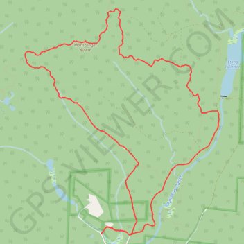
Mount Singer
Montagnes-Vertes Nature Reserve. #Hike #Snowshoes #Loop #MontagnesVertes #Nature
- Distance: 14.2 Km
- Elevation gain: 601 m
- Maximum elevation: 800 m
- Elevation loss: 601 m
- Minimum elevation: 284 m
Interactive map
GPS track profile
About this GPS track
Name: Mount Singer GPS track, route, trail
Start: MontagnesVertes-Decouvertes, Potton, Memphrémagog, Estrie, Quebec, Canada (45.10438 -72.45273)
End: MontagnesVertes-Decouvertes, Potton, Memphrémagog, Estrie, Quebec, Canada (45.10438 -72.45273)
Coordinates: 45.10412 -72.46921 45.13825 -72.42766
Other GPS tracks
Click on a GPS track to view route, its statistics and profile.