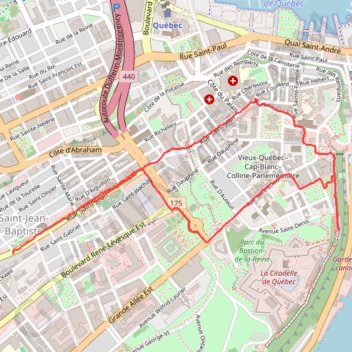
Balade dominicale dans le Vieux-Québec
Randonnée en boucle par la Rue Saint-Jean, l'Église Saint-Jean-Baptiste, la Bibliothèque Claire-Martin, l'Hôtel de Ville de Québec, la Basilique cathédrale Notre-Dame-de-Québec, la Place d'Armes, le Château de Frontenac, la Citadelle de Québec, la Rue Saint-Louis et l'Hôtel du Parlement. #Randonnée #Boucle #Ville #Château #Parc
- Distance: 4.2 Km
- Elevation gain: 77 m
- Maximum elevation: 80 m
- Elevation loss: 89 m
- Minimum elevation: 41 m
- Moving time: 1 h 7 m
- Moving speed: 3.7 Km/h
- Maximum speed: 6.9 Km/h
- Total time: 1 h 22 m
- Global speed: 3.0 Km/h
- Date: 25/02/2024
Interactive map
GPS track profile
About this GPS track
Name: Balade dominicale dans le Vieux-Québec GPS track, route, trail
Coordinates: 46.80843 -71.22360 46.81485 -71.20402
Other GPS tracks
Click on a GPS track to view route, its statistics and profile.
Trois-Rivières - Québec
Canada > Quebec > Trois-Rivières
#Bike
Distance: 138.5 Km • Elevation gain: 838 m • Maximum elevation: 108 m
Portneuf - Québec
Canada > Quebec > Portneuf (MRC) > Portneuf
Saint Lawrence River. #Bike #Portneuf #Québec #SaintLawrence
Distance: 66.8 Km • Elevation gain: 547 m • Maximum elevation: 90 m
Québec - Saint-Jean-Port-Joli
Canada > Quebec > Urban agglomeration of Québec > Quebec
Saint Lawrence River. #Bike #Québec #SaintJeanPortJoli
Distance: 95.2 Km • Elevation gain: 476 m • Maximum elevation: 82 m