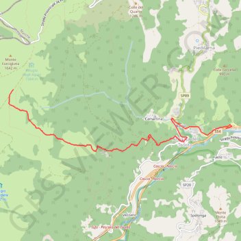
Forca di Presta - Arquata
VTT. En aller simple. #VTT
- Distance: 7.2 Km
- Elevation gain: 27 m
- Maximum elevation: 1,540 m
- Elevation loss: 961 m
- Minimum elevation: 603 m
- Moving time: 30 m 50 s
- Moving speed: 13.9 Km/h
- Maximum speed: 52.6 Km/h
- Total time: 32 m 41 s
- Global speed: 13.2 Km/h
- Date: 07/08/2012
Interactive map
GPS track profile
About this GPS track
Name: Forca di Presta - Arquata GPS track, route, trail
Start: Strada provinciale di Castelluccio, Norcia, Perugia, Ombrie, 06046, Italie (42.78151 13.25556)
Coordinates: 42.77060 13.25452 42.78151 13.30780
Other GPS tracks
Click on a GPS track to view route, its statistics and profile.
Tour d'Europe
France > Bretagne > Finistère > Concarneau > Landan Creis
Distance: 7,132.9 Km • Elevation gain: 44,603 m • Maximum elevation: 2,433 m
Percorso selezionato
Italie > Lombardie > Côme > Côme
Percorso calcolato con http://www.bicitalia.org/it/routing-gpx
Distance: 1,543.9 Km • Elevation gain: 17,951 m • Maximum elevation: 1,034 m
De Giromagny à Sofia
France > Bourgogne-Franche-Comté > Territoire-de-Belfort > Giromagny
Distance: 1,875.9 Km • Elevation gain: 12,108 m • Maximum elevation: 1,054 m
Trace Les Balkans
Italie > Frioul-Vénétie julienne > Pordenone > Versutta
Distance: 2,720.6 Km • Elevation gain: 41,224 m • Maximum elevation: 1,799 m