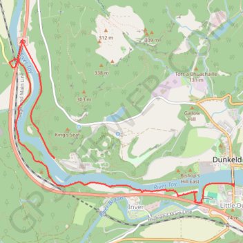
Walk over A9 bridge over River Braan by pedestrian pavement (sidewalk) and small diversion for SGN gas pipeline route then Fiddlers path
- Distance: 6.0 Km
- Elevation gain: 79 m
- Maximum elevation: 76 m
- Elevation loss: 64 m
- Minimum elevation: 48 m
- Moving time: 1 h 14 m
- Moving speed: 4.8 Km/h
- Maximum speed: 14.0 Km/h
- Total time: 1 h 16 m
- Global speed: 4.7 Km/h
- Date: 21/04/2024
Interactive map
GPS track profile
About this GPS track
Name: Walk over A9 bridge over River Braan by pedestrian pavement (sidewalk) and small diversion for SGN gas pipeline route then Fiddlers path GPS track, route, trail
Start: Dunkeld Bridge, Dunkeld, Perth and Kinross, Scotland, PH8 0AF, United Kingdom (56.56329 -3.58516)
End: A9, Inver, Perth and Kinross, Scotland, PH8 0JR, United Kingdom (56.56569 -3.61595)
Coordinates: 56.56141 -3.62376 56.57691 -3.58509
Other GPS tracks
Click on a GPS track to view route, its statistics and profile.