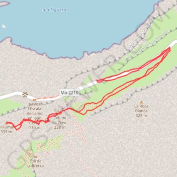
El Fumat
Randonnée en aller-retour par le Coll de la Creu. #Randonnée #Majorque #guillaumevk
- Distance: 2.8 Km
- Elevation gain: 193 m
- Maximum elevation: 315 m
- Elevation loss: 200 m
- Minimum elevation: 149 m
- Moving time: 1 h 48 s
- Moving speed: 2.7 Km/h
- Maximum speed: 5.4 Km/h
- Total time: 1 h 11 m
- Global speed: 2.3 Km/h
- Date: 26/09/2020
Interactive map
GPS track profile
About this GPS track
Name: El Fumat GPS track, route, trail
Start: Ma-2210, Pollença, Serra de Tramuntana, Îles Baléares, Espagne (39.95014 3.18065)
End: Ma-2210, Pollença, Serra de Tramuntana, Îles Baléares, Espagne (39.95020 3.18059)
Coordinates: 39.94814 3.17575 39.95159 3.18462
Other GPS tracks
Click on a GPS track to view route, its statistics and profile.
Southern section — European Divide Trail
France > Auvergne-Rhône-Alpes > Drôme > Valence
Distance: 2,423.8 Km • Elevation gain: 42,375 m • Maximum elevation: 2,005 m
1 LUCENA - MONTPELLIER
Distance: 2,964.4 Km • Elevation gain: 29,500 m • Maximum elevation: 1,048 m
1 LUCENA - MONTPELLIER
Espagne > Andalousie > Lucena
Distance: 2,964.4 Km • Elevation gain: 29,500 m • Maximum elevation: 1,048 m
Stage 26: Valence to Saint-Jean-de-Fos — European Divide Trail
France > Auvergne-Rhône-Alpes > Drôme > Valence
Distance: 2,423.8 Km • Elevation gain: 42,375 m • Maximum elevation: 2,005 m
Stage 26: Valence to Saint-Jean-de-Fos — European Divide Trail
France > Auvergne-Rhône-Alpes > Drôme > Valence
Distance: 1,629.8 Km • Elevation gain: 30,841 m • Maximum elevation: 2,005 m