Killinkere
Lunch Run
- Distance: 12.7 Km
- Elevation gain: 136 m
- Maximum elevation: 146 m
- Elevation loss: 141 m
- Minimum elevation: 99 m
- Moving time: 1 h 6 m
- Moving speed: 11.4 Km/h
- Maximum speed: 23.0 Km/h
- Total time: 1 h 6 m
- Global speed: 11.4 Km/h
- Date: 18/04/2024
Interactive map
GPS track profile
About this GPS track
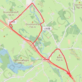
Name: Killinkere GPS track, route, trail
Coordinates: 53.87827 -7.17576 53.91166 -7.12834
Other GPS tracks
Click on a GPS track to view route, its statistics and profile.
RT5-1 Rosslare - Kinsale
Distance: 2,860.3 Km • Elevation gain: 27,381 m • Maximum elevation: 420 m
RT5-1 Rosslare - Kinsale
Distance: 3,867.1 Km • Elevation gain: 36,115 m • Maximum elevation: 524 m